
Madhumati Nallah: From Glacial Source to Fading Springs
Written by: Dr. Peerzada Muneer
Bandipora, a small Himalayan district on the northern fringe of Kashmir valley, has long been known as a landscape of water, framed by the vast expanse of Wular Lake and fed by a dense network of streams, springs and snowfed nallahs that descend from the Harmukh range. Wular itself occupies the lowest part of this basin and receives inflows from the Jhelum, from major northern tributaries such as Madhumati and Arin, and from dozens of smaller mountain torrents that together create one of the most water rich micro landscapes in the western Himalaya. This convergence of surface water is complemented by a dense constellation of springs and wetlands which, historically, have moderated floods, recharged groundwater and provided a buffer in times of scarcity for settlements scattered between the foothills and the lake shore.
Within this watery geography, Madhumati nallah occupies a central place, both physically and in local memory. Rising in the high, glaciated recesses of the Lashan Pinjan system on the northern slopes of Harmukh, Madhumati begins as a composite of meltwater streams that drain cirques, hanging valleys and small lakes in the upper catchment. The Lashan Pinjan glaciers and snowfields act as a cold reservoir that captures winter snowfall and releases it gradually during the spring and summer months, giving Madhumati a characteristic hydrograph with low winter baseflow and strongly rising discharge from March onwards. As the small torrents emerging from the ice merge and grow, they first cut through steep rock and scree, then through alpine meadows used seasonally by pastoralists, before entering a more defined valley that guides the nallah towards the settled belt of Bandipora.
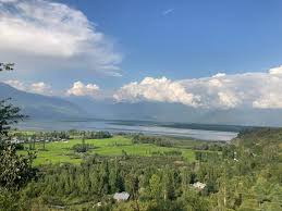
Historically, the origin of Madhumati in high mountain ice and snow has mattered less to local people than the fact that it is a perennial, cold and relatively clean stream that reaches them reliably each year. Yet this glacial and nival source is crucial in explaining why the nallah has retained flow even in weak monsoon years, and why its temperature and clarity have supported trout and other cold water biota in the middle reaches. As it travels downstream from the Lashan Pinjan zone, Madhumati is joined by tributaries such as Vija Nar and Harpat Nar near Panar, which increase its discharge and sediment load and contribute to the formation of a broad alluvial fan on which much of Bandipora town and its surrounding villages are located. (Wetlands International) The stream then flows past settlements like Bonakut, skirts the urban fabric of Bandipora, and eventually enters Wular Lake near Dachigam, not far from the Kaloosa bridge, where its waters mix with those of Arin and the Jhelum.
In this journey from source to sink, Madhumati stitches together a remarkable series of ecological zones and human uses. In the upper reaches, near Lashan Pinjan and associated lakes, the nallah is framed by high altitude pastures where Gujjar and Bakkerwal herders move with their flocks for a brief summer season, depending on the reliability of snowmelt for grazing and drinking water. Midway down, in the Panar–Bonakut belt, it becomes an organizing line for agriculture, with terraces, orchards and homesteads oriented to its course and to the canals that branch from it. In its lowest stretch, as it enters Wular, Madhumati is less a solitary stream than an arm of a larger wetland system that sustains fisheries, aquatic vegetation and flood storage for the Jhelum basin as a whole. (Wetlands International)
The seasonal rhythm of Madhumati is most evident in the transition from spring to summer, when the effect of Lashan Pinjan’s stored snow and ice is felt most strongly in Bandipora’s fields and orchards. As temperatures rise in March, increased solar radiation initiates melt in the accumulation zones of the glacier and surrounding snowfields, and a distinct rise in discharge is recorded at Wular’s inflow points. Hydrological assessments of the Wular catchment indicate that nearly 80 percent of total annual inflow to the lake occurs during the summer months, with snowmelt playing a dominating role in the period from spring to early monsoon. Madhumati follows this pattern, swelling in volume, widening its channel and carrying a higher load of fine sediments as it moves through April, May and June.
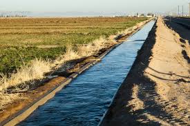
In these months, the nallah is both at its most beautiful and its most useful. The banks green quickly, willows and poplars leaf out, and the sound of fast water becomes the background to sowing and transplanting activities in the surrounding villages. Farmers in Bandipora’s mid level villages depend on the gravity driven flow of Madhumati, often harnessed through traditional intakes and small canals, to irrigate paddy fields laid out on gentle slopes and valley bottoms. The direct Wular catchment contains around 339 square kilometres of agricultural land, of which only about 55 percent is currently irrigated, underscoring the importance of nallahs like Madhumati and the canals associated with them in determining which fields can support water intensive crops such as rice. (Wetlands International) In areas where Madhumati’s flow can be easily diverted, orchards of apple and walnut on lower Karewa slopes also benefit from supplemental irrigation in the drier parts of the season, helping to stabilize yields in the face of rainfall variability.
Beyond surface irrigation, Madhumati’s spring and summer flows play a subtle role in recharging shallow aquifers along its course. Where the channel runs through permeable alluvium, a portion of its discharge seeps laterally into the surrounding sediments, raising groundwater levels and sustaining village springs and wells that lie some distance from the nallah itself. This interaction between stream stage and groundwater levels is particularly important for households whose access to the main channel is limited by distance, terrain or land ownership, but who can still rely on springs and hand pumps during the high flow season. As the season advances and discharge slowly declines after the monsoon, these groundwater stores help bridge the gap, allowing perennial springs to continue supplying water for domestic use and small kitchen gardens even when the visible presence of Madhumati seems reduced.
Madhumati’s importance, however, extends beyond Bandipora’s immediate surroundings, reaching as far as Sopore and the Zainageer tract on the other side of Wular. The connective element here is the system of canals whose origins lie in the fifteenth century, when Sultan Zain ul Abidin (Budshah) undertook major irrigational reforms across Kashmir. One of the most significant canals he commissioned is Nahr e Zainageer, also known as the Zainagir canal, which carries water to the fertile Zainageer belt near Sopore. Historical and scholarly work on these reforms notes that Nahr e Zainageer is about 47 kilometres long and that its source lies in a sublet of Nallah Madhumati in Bandipora district, effectively linking the Lashan Pinjan fed stream to the irrigation system of Zainageer.
The same study estimates that the Zainageer canal irrigates around 12,900 acres of land, supporting paddy cultivation and other crops in what would otherwise be a much drier landscape between Wular and the left bank of the Pohru river. In everyday terms, this means that during the crucial summer months the snow and ice that melt at Lashan Pinjan, flow as Madhumati, pass through Wular and are tapped by the canal network ultimately determine water availability in Sopore’s fields and orchards. When Madhumati’s discharge is strong and Wular’s storage capacity is healthy, the canal can draw and distribute water more reliably across its 47 kilometre length; when flows are impaired or the lake’s buffering function is weakened, farmers in Zainageer may experience shortages at precisely the stages when their crops are most water sensitive. The hydrological link between Bandipora’s glacier fed nallah and Sopore’s agricultural prosperity is thus intimate, even if it is not always visible in public discourse.
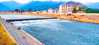
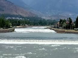
Bandipora’s district disaster management plan notes that Madhumati and Arin are not only key irrigation sources but also famous for trout, indicating that the water quality, temperature and flow conditions have historically supported cold water fisheries. For fishing communities on Wular’s shores and in the nallahs themselves, this has provided an important supplementary livelihood and a source of protein in local diets. Madhumati also figures in more recent infrastructure efforts, including the construction of a reinforced concrete cement weir by the Irrigation and Flood Control Department, intended to regulate flows and enable small hydro energy distribution while stabilizing water availability for downstream uses. Such structures signal a shift from purely gravity and tradition based water sharing towards more engineered control, which has implications for both ecological continuity and local notions of water rights.
Against this backdrop of multiple benefits, the increasing intensity of sand and aggregate mining along Madhumati poses a serious threat to both the stream and the communities that depend on it. Catchment assessments for Wular identify quarrying and in channel extraction of sand and gravel in the Bandipora–Madhumati sector as activities that have “severely altered the natural siltation profile” of the system. In the Madhumati basin specifically, sand and bajri mining have been reported near Kaloosa and other accessible stretches of the nallah where demand from the construction sector is high. Removing large quantities of sand from the channel bed changes the cross section and gradient of the stream; mining pits deepen local segments of the bed, and flow responds by eroding upstream and downstream reaches as it attempts to restore a more uniform profile. (Wetlands International)
One immediate consequence of this bed degradation is a lowering of the local base level, which alters the relationship between Madhumati and its adjacent groundwater system. In places where the stream once recharged shallow aquifers, the deepened channel can begin to act as a drain, accelerating the outflow of groundwater and causing water tables in nearby wells and springs to fall. Springs that previously emerged at or just above the valley floor may dry up or become strongly seasonal, forcing households to seek water from more distant sources or to invest in deeper, more expensive borewells. Reports from the broader Wular catchment highlight how communities, especially women, now have to walk greater distances for both water and fuelwood as forest lines retreat and local sources decline, illustrating the cumulative burden of environmental degradation.
Deepened channels also destabilize banks, making the soils along the nallah more prone to erosion. When the bed is lowered, side gullies gain more vertical distance to erode before meeting the main stream, which can trigger incision in small tributaries that cut into agricultural terraces and village infrastructure. During intense rainfall events, especially in the monsoon months, these destabilized banks are more likely to fail, resulting in small landslides or slumps that carry valuable topsoil into the nallah and further increase sediment loads entering Wular. Farmers with land immediately adjacent to Madhumati thus experience not only the loss of land to erosion but also the slow undermining of tree roots and field boundaries that had seemed secure for generations.
At the scale of Wular Lake, excessive sediment contributions from degraded catchments like Madhumati have already had measurable impacts. Studies using remote sensing and field data have documented that Wular’s open water area has shrunk significantly over recent decades, largely because of extensive plantation and agricultural encroachment in the lake’s shallow margins coupled with increased sedimentation. Since Madhumati is one of the major northern inflows, its altered sediment regime contributes to this infilling, reducing Wular’s storage capacity and its ability to modulate floods and provide a stable baseflow for downstream irrigation, including in Sopore and Zainageer. (Wetlands International)
For communities living along Madhumati, these hydrological and geomorphological changes translate into a complex mixture of insecurity and loss. Springs that have gone dry or turned intermittent are not only functional infrastructure failures but also cultural losses, because they often carried local names and stories that anchored people to place. As groundwater tables deepen, the practical possibility of accessing water through traditional dug wells diminishes, especially for poorer households who cannot afford deep drilling or motorized pumps. Soil erosion and bank collapse eat into marginal lands first, disproportionately affecting those whose holdings are already small and whose resilience is weakest.
Soil conservation experience from other parts of Jammu and Kashmir shows that such trajectories are not inevitable. The state’s soil conservation programmes have deployed a range of measures, including vegetative barriers, check dams, dry stone masonry (DRSM) structures and afforestation, which have successfully reduced erosion and stabilized gullies in treated microwatersheds. Applying similar approaches in the Madhumati catchment, combined with strict regulation and eventual phasing out of in channel sand mining, could help raise groundwater levels, secure spring flows and protect agricultural land, thereby benefiting both Bandipora and Sopore’s Zainageer belt which depend on these waters in different but connected ways.
Seen as a whole, Madhumati nallah is not simply a local stream but part of a continuous circulation of water that begins in the ice and snow of Lashan Pinjan, passes through the fields and homes of Bandipora, rests briefly in the spread of Wular, and then moves on to feed canals and rivers that irrigate Sopore and Zainageer. The statistics of canal length, irrigated acreage and shrinking lake area offer quantitative glimpses into this system, but the lived reality is captured in more intimate scenes: the first spring trickle in a village spring, the sound of high summer water rushing past an orchard, the anxiety of a farmer watching bank erosion creep closer to his land.